 |
| |
Protected Areas Of Honduras
|
|
A total of 95 protected areas in Honduras are registered members of the SINAPH (Honduras National System of Protected Areas). Our North Coast boasts a rich biodiversity of marine and terrestrial protected areas. Under REHDES leadership 8 North Coast Ngo’s such as (Aecopijol, BICA, Fundacion Cayos Cochinos, Fucsa, Fupnand, Fucagua, Prolansate, Fupnapib) have signed protected areas management agreements with the government of Honduras since 1996.
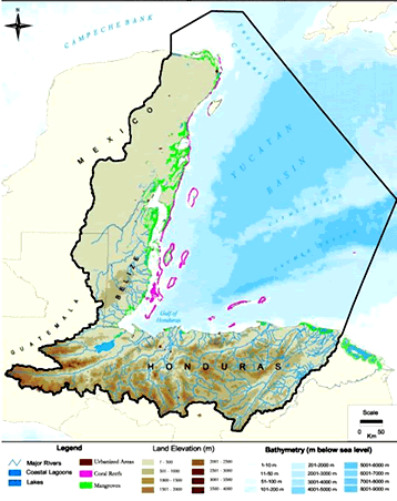
In the context of the Mesoamerican Barrier Reef the Bay Islands is defined as a high priority area for its rich biodiversity. The MAR is considered a Caribbean jewel in the Western Hemisphere; shared by 4 countries, extending 1000 kilometers from the North of the Yucatan Peninsula, Belize, Guatemala to Cayos Cochinos and the Bay Islands reef system adjacent to the Honduran North Coast. |
|
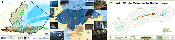 |
BAY ISLANDS PROTECTED AREAS
The Bay Islands protected areas are important terrestrial and marine parks of local, national, regional and international significance. These are Guanaja: Half Moon Cay- South West Cay, Michael Rock; Utila: Raggedy Cay – South West Cay, Zona de Proteccion Especial Marina Turtle Harbour – Rock Harbour; Roatan Zona de Proteccion Especial Marina Santa Elena – Barbareta, Zona de Proteccion Especial Marina Sandy Bay West End or Sandy Bay – West End National Marine Park.
The terrestrial parks are: Port Royal National Park, Municipality of Santos Guardiola on Roatan; Utila Turtle Harbour Wildlife Refuge and on Guanaja the Zona Forestal Reservada #3 with Legislative Decree since 1960. |
|
MARINE PROTECTED AREAS.
The archipelago of the Bay Islands located 40 miles off the North Coast of Honduras supports coral reefs, sea grass flats, productive marine banks, flats and mangrove forest. This rich and vibrant biodiversity is ideal for conservation and economically important for the local population that depends on these resources for their livelihood and future development.
SANDY BAY - WEST END MARINE PARK
Located on the Northwest coast of the island of Roatan, encompasses the communities of Sandy Bay, West End, West Bay, and Key Hole on the South side of the island, extending from the high water mark outward 2 miles, extending 17 miles of coastline and 10,400 square miles of reef. |
|
 |
REGULATIONS
- No spear fishing. It’s illegal in the Bay Islands.
- Do not touch, or remove live marine organisms such as hard or soft corals, shells, fish or other forms of marine life
- Do not throw trash in the sea, creeks or on the beaches,
- Do not discharge bilges near reef of beaches.
- Do not drop anchors directly on the reef.
- Do not stand or sit on the coral, it damages the life and structure of the reef.
- Do not feed fishes and other marine life.
- Do not use gloves.
- No jet skies, jet bikes (West Bay).
|
|
|
Located in the Municipality of Santos Guardiola this unique forest is the only terrestrial protected area on the island of Roatan, supports endemic fauna such as Yellow Napped Parrots (Amazona auropalliata caribaea), Guatuza (Dasyprocta ruatanica), Marmosa rataunica. and unique flora such as Pinus caribea. Endangered species such as White Tail Deer, Green Iguanas, spectacular panoramic views are also common here. This 499.25 hectares of forest extends from Jane Cooper Hill in Calabash Bight Eastward to the West of Camp Bay. Picacho is the highest peak inside the park. Nearby attractions include Camp Bay Beach. |
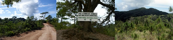 |
REGULATIONS
Do not start forest fires
Do not hunt wildlife
Do not litter roadside and trails |
|
|
|

